Matajur
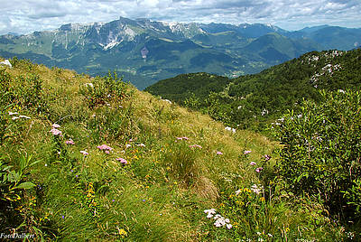
The mountain’s gentle slopes, clothed in woods (poplars, chestnuts, mountain alders) and meadows as far as the summit, present no particular challenge to an ascent. The quickest and simplest route to the summit is from the Pelizzo refuge, which can be reached by car along a well-maintained tar road. An alternative route starts at the village of Mersino, and follows mule trails and footpaths to reach the summit in an easy journey of roughly one and a half hours, passing through woods and meadows where narcissi, crocuses, strawberries, raspberries and bilberries grow.
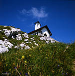
The little church of Cristo Redentore stands on the summit. It was built on the ruins of the chapel inaugurated in 1901 to commemorate the nineteen centuries since the Redemption, before being struck by lightning and subsequently destroyed in actions associated with the battle of Caporetto.
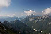
The summit offers a magnificent view, taking in Carso and Istria, the Grado lagoon, the summits of Canin, Mangart, Tricorno, Monte Nero, and the Dolomites.
Streams and rivulets that swell the Natisone river spring from Matajur’s slopes, which, in the Savogna valley, are also the source of the Alberone river and the tributaries of its right bank.
The area around Mount Matajur, particularly the Savogna valley, contains a number of notable cave systems. Among those that deserve mention are Cerconizza, Ta Pot Čelan Jama, Velika Jama, Mersino Alto, Sesna Jama in Mersino, Casera Glav in Masseris and Jeronizza.
Since remote times the peak has marked a boundary, first with Austria, later with Yugoslavia, and today with the Republic of Slovenia.
The SS54 highway runs below Matajur’s northern flanks, providing the most convenient route between Italy and Slovenia and to the middle stretches of the Isonzo river.
The mountain and its slopes are crossed by CAI (Club Alpino Italiano) paths 736 and 725 and Sentieri Italia path 749.
The name Matajur did not appear in maps and documents until the 18th Century. It is a derivation of Mont Major (Monte Maggiore di Cividale) which, over time, mutated into Mot Major, Mat Major, Matajor and, finally, Matajur. Locally it is also known as (Velika) Baba, meaning an isolated rocky peak, or, from the last century, Kalona, which refers to the obelisk erected alongside the chapel of Cristo Redentore and destroyed during the First World War, as noted above.