Cave del Predil
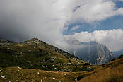
Itinerary, Cave del Predil - Sella delle Cave - Valle di Riofreddo - Riofreddo - Muda - Cave del Predil: Excursion time 5.00 hoursDegree of difficulty ExcursionResting points Bars and restaurants in Cave del Predil From the residential area of Cave del Predil (900 m.) take the asphalt road, which, after having crossed Rio del Lago , runs alongside the mine and leads to the outlying ward of Caroli . From here, proceed along a forest road and after a series of bends, near a clearing (1014 m.), leave the road and proceed along a trail to the right, which goes upwards to Sella delle Cave . This section of the trail goes along a woody slope where there are various forest species including: spruce, silver fir, beech, maple, elm, laburnum and others. After having reached Sella (1334 m.) a downwards section starts, which has many panoramic views across Cima del Cacciatore , Cima di Riofreddo and Cima delle Rondini . After having crossed the small torrent called Rio Freddo (1012 m.) the descent ends and you come to a meadow clearing. From here go down towards the right along a forest trail that runs alongside the Rio and the valle di Riofreddo which has the same name, set in between Cima del Cacciatore (on the left) and Mount Re ( on the right). After a pleasant walk you come to the small outlying ward of Riofreddo (817 m.) and the crossroads with the main road toward the Predil pass. After having taken the trail to the right and cross the bridge over Rio del Lago you return to Cave del Predil. The first part of the main road consists of a few bends, which can be avoided by taking the trail that branches off shortly after the bridge over Rio del Lago. This trail, which coincides with the old road, starts near the Madonnina and leads to the outlying ward of Muda (870 m.).MOUNT RE - 1912 m. (excursion variant)from the forest road that crosses the outlying ward of Caroli , rather than turning at the crossroads along the previous trail (1014 m.), proceed for a short distance to the end of the road (1023 m.) At the old mine buildings, take the well-signalled trail leading to the tip of Mount Re (1912 m.) where there is a beautiful cross in the form of a crown and a book of the summit. From the peak, there is a extensive view of the main peaks of the Julian Alps (Jof Fuart and Jof di Montasio, Canin and Mangart), of the Carnic Alps and part of the Valcanale.