THE TORRE VALLEYS
The territory of the Torre Valleys is located in the central part of the arc of the Julian Prealps. It skirts the fringes of Udine’s urban strip to the south, rises in the east to the Italian-Slovenian border alongside the Natisone Valleys, marks out the Resia Valley with the Musi range to the north, and borders the Gemonese area to the west.
The territory is oriented principally along a south-north line, becoming gradually more elevated to the north. The southern zone gravitates to the Udinese plains below, in more than the geographical sense alone, while the higher altitude northern zone is more isolated and self-contained.
In appearances and form it is essentially a landscape of transition, variable in both its natural and anthropic aspects, and can be categorised according to criteria of latitude and altitude into:
- a plains zone
- a hill zone
- a sub-mountain zone
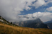
- a mountain zone
The orography features a series of spur ridges rising from the plains and becoming progressively higher, oriented on an east-west axis (Alpine orogenic spurs) in the north and west, and on a northeast–southwest axis (Dinaric orogenic spurs) towards the south and east. Thus it is that the river valleys of the Torre and the Cornappo follow a north-south line, while the Lagna Malina and Grivò rivers have cut a northeast-southwest course. From north to south the mountains become progressively lower and flatter: this can be seen as a consequence of the varying erosion resistance of the rock: calcite and dolomite to the north, terrigene complexes (calcarenite, marls, sandstone) to the south.
The orographic features described above influence both the climate and, ultimately, the locations of human settlements and the productive capacity of the land.
From a hydrographic standpoint, this area forms part of the Isonzo basin, and can be subdivided into the following river sub-basins (from west to east): Urana and Ledra, Torre (principal sub-basin), Cornappo, Malina, Natisone and Grivò.
The hydrographic network of the surface is quite dense, and is responsible for a notably complex orography on the one hand, and an unusual abundance of water, which has a marked effect on the landscape, on the other.